Join Curify to Globalize Your Videos
or
By using Curify, you agree to our
Terms of Service and Privacy Policy
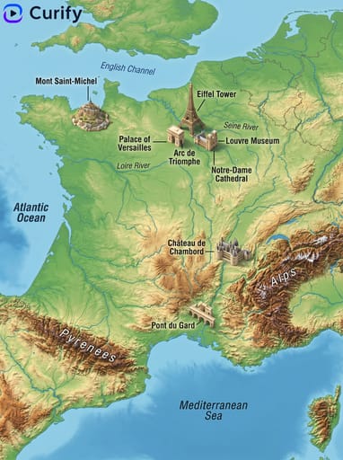
3D Region Landmark Map of the USA – Explore Iconic Sites
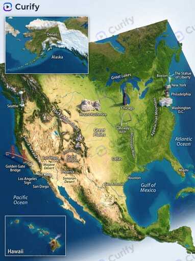
This stunning 3D Region Landmark Map of the USA showcases iconic landmarks and geographical features in a captivating visual format. Ideal for educators looking to enhance geography lessons or travelers seeking to explore the country's rich architecture and history. Whether you're creating infographics or city guides, this template offers a unique perspective. Dive into the world of 3D mapping and start generating your own engaging content with our AI prompt today!
Generate your own
Region/Country Name
Prompt
(3D Relief Map Illustrator)You are a professional 3D relief map illustrator. Based on the user-specified usa, generate a high-quality, photorealistic 3D topographical map of the region, matching the detailed, vibrant style of the reference images. Layout: 1. Map Base: Accurate 3D relief topography with realistic elevation shading, detailed rivers, lakes, and oceans, natural color gradients. 2. Landmark Overlays: Small detailed 3D models of major landmarks placed at correct locations, clear bold text labels for landmarks, cities, regions, and bodies of water. Style: Photorealistic high-resolution 3D map art, natural lighting, clean labeling, vertical format, 4K ultra HD, direct image generation. Subject: 3D Relief Topographical Map of usa with Landmarks.
Use this example for
More like this

Other nano banana templates
Explore other categories and presets.