Join Curify to Globalize Your Videos
or
By using Curify, you agree to our
Terms of Service and Privacy Policy
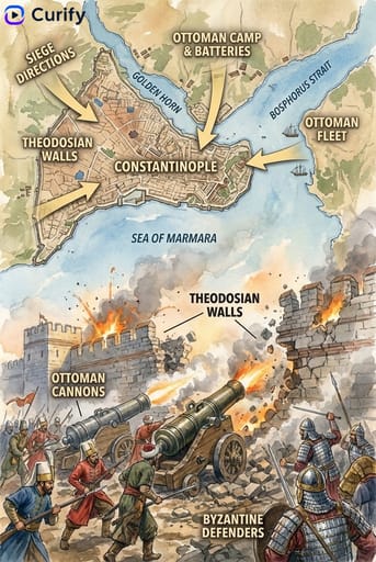
Bering Land Bridge Migration - Historical Event Map Illustration
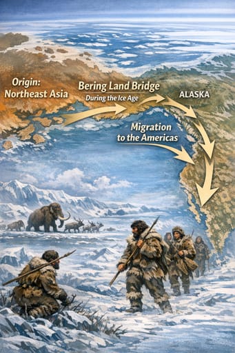
This stunning historical event map illustration depicts the Bering Land Bridge migration, showcasing the ancient route taken by early humans into North America. It serves as an educational tool for teachers, students, and history enthusiasts alike, facilitating a deeper understanding of this significant migration event. With its intricate details and informative layout, this template is ideal for creators looking to visualize historical narratives. Discover how easy it is to generate your own unique AI prompt or illustration that brings history to life!
Generate your own
Historical Event Name
Prompt
(Historical Event Map Illustrator) You are a professional historical infographic designer. Based on the user-specified bering land bridge migration, generate a vertical, two-part map and scene illustration, matching the watercolor/illustrative style of the reference images. Layout: 1. Top Section: Detailed map showing the event's route, key locations, and directional arrows, with clear labels for cities, regions, and bodies of water. 2. Bottom Section: Vivid, dramatic scene illustration depicting the key moment of the event (battle, march, disaster, etc.). 3. Header/Title: Bold title "{historical_event.upper()}" with a subtitle/date, Curify watermark at top left. Style: Warm, illustrative watercolor texture, historically accurate details, clear typography, vertical format, 4K ultra HD, direct image generation. Subject: bering land bridge migration Illustrated Route & Scene Map.Use this example for
More like this
Other nano banana templates
Explore other categories and presets.